China Weather Network News This morning (July 24th), the No.5 typhoon "Du Surui" this year has been strengthened to a strong typhoon level, and it will become a super typhoon tonight, and it will probably land in Fujian or Guangdong as a typhoon or strong typhoon level later, which may become the strongest typhoon landing in China this year. Affected by this, Taiwan Province, Fujian, Zhejiang and other places have experienced strong winds and heavy rains, and some areas may break the precipitation record in the same period. What are the characteristics of Du Surui? What other changes have taken place in its path trend? When does it enter the core period of influence?
Typhoon "Du Surui" strengthened rapidly in two days, and the strongest typhoon could reach super typhoon level.
At 08: 00 on July 21, the No.5 typhoon "Du Surui" was generated this year, and it has been moving slowly in the east of the Philippines since then. In recent two days, "Du Surui" has strengthened rapidly, strengthening to a strong tropical storm level at 05: 00 on the 23rd, a typhoon level at 17: 00 on the 23rd, and a strong typhoon level at 24: 08.
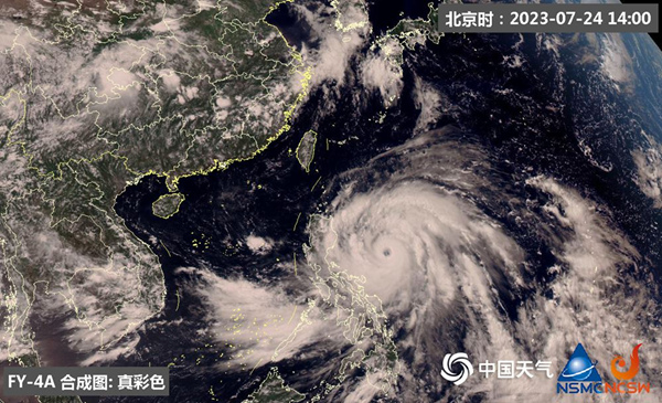
"Du Surui" is huge and the cloud system is complete. (Photo/National Satellite Meteorological Center)
"Typhoon ‘ Du Surui ’ It has the characteristics of strong strength, strong wind and rain and wide influence. " According to Zhang Juan, a meteorologist of China Weather Network, from the cloud image, the typhoon eye of Du Surui is clear and complete at present; The southwest monsoon on the south side continuously gives water vapor and energy support, and the wispy high-level outflow cloud system can be clearly seen on the east side, which means that the pumping effect of high-altitude outflow is also strong; Coupled with the current high sea temperature conditions, these are conducive to the enhancement of typhoon intensity. It is estimated that the peak intensity of Du Surui can reach the super typhoon level.
There are still variables in the trend of Du Surui’s high probability landing in Fujian or Guangdong coastal areas.
At 14: 00 this afternoon, the center of Typhoon Du Surui was about 900 kilometers southeast of Taiwan Province’s Eguanbi. It is estimated that it will move to the northwest at a speed of 10-15 kilometers per hour, and its intensity will continue to strengthen. The strongest typhoon level can reach (the strongest wind force near the center is 16-17), and it will gradually approach the southern coast of Taiwan Province Island, possibly passing through or landing on the southwest coast of Taiwan Province, then approaching the coast of Fujian, landing on the coast of Fujian in the morning of the 28th, and moving to the north-west direction after landing.
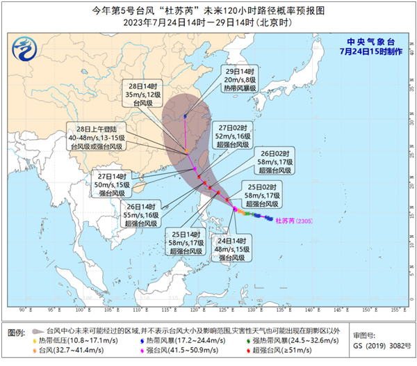
Zhang Juan reminded that there are still variables in the path trend of "Du Surui", and the specific direction depends mainly on the "face" of the subtropical high. If the subtropical high is stronger, the weight of the typhoon going west will increase, and there is the possibility of landing in eastern Guangdong; If the subtropical high weakens, the typhoon track will be northward, and the possibility of passing by or landing in Taiwan Province will increase. "Du Surui" may avoid Luzon Island in the Philippines and Taiwan Province Island in China, and become a first-hand typhoon landing in Fujian or Guangdong, which will have a greater impact on the wind and rain, and the change of landing location will affect the change of the core rainfall area. The public should pay close attention to the typhoon trends and trends and make preparations for typhoon defense in advance.
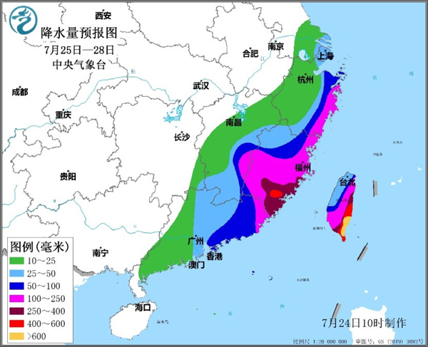
Taiwan Province, Fujian, Zhejiang and other places with strong winds and heavy rains may break the precipitation record in the same period.
Under the influence of Du Surui, it is estimated that there will be 9-11 winds and 12-14 gusts in bashi channel, the southeast of Taiwan Province, the Taiwan Province Strait, the southern coast of Taiwan Province Island and the south-central coast of Fujian from 24th to 29th. The winds in the nearby sea or areas where Du Surui Center passes are 12-16, and the gusts can reach 17 or above.
"The impact of typhoon on China’s rainfall will gradually appear from tomorrow." Zhang Juan said that from the night of the 25th, the rainfall in southeastern Taiwan Province will gradually increase; From 27th to 29th, it is the main period affected by typhoon. Among them, there will be heavy rain or even heavy rain in most parts of Taiwan Province on the 27th, and there may be heavy rain or heavy rain in Fujian and southern Zhejiang on the 28th, and some areas may break the precipitation record in the same period.
Typhoon "Du Surui" struck hard. Keep this scientific defense guide.
Typhoon Du Surui’s peak intensity can reach super typhoon. Whether it lands in Taiwan Province, Fujian or Guangdong, it will bring strong wind and rain, which will seriously affect the daily life of local people. So, what preparations do residents need to make before the typhoon comes? How to avoid danger when a typhoon comes?

Before the typhoon comes, residents should listen, watch or check the typhoon warning information in time to understand the government’s typhoon prevention measures; Then close the doors and windows, and turn off computers, televisions and other electronic equipment; Reserve food and water, and prepare emergency items such as mobile power supply and flashlight; Check whether the circuit, fire, gas and other facilities are safe; Residents living in all kinds of dilapidated houses, factories and sheds should be moved to safety in time; If you are already in a solid house, you can stick a "meter" pattern on the window glass with adhesive tape to prevent the window glass from breaking.

When the typhoon comes, you should continue to pay attention to the dynamic information of the typhoon. It is best not to go out. If you are outside, don’t take shelter from the wind and rain near temporary buildings, billboards, iron towers and trees. If you drive, you should immediately drive to the underground parking lot or shelter; If you are in a tent, you should immediately put away your tent and take shelter from the wind in a solid house; If you are on the water, you should immediately go ashore to take shelter from the wind and rain. (Text/Song Huacheng Design/Luo Jiaxue Data Support/Zhang Juan)
关于作者