China Weather Network News Today (October 3), the rainfall in West China will be reduced and weakened, but a new round of rainfall will start again tonight, with heavy rain and local heavy rain in some areas; At the same time, there are blizzards or heavy blizzards in Qinghai and Gansu, so it is necessary to pay attention to prevention. In terms of temperature, the northeast region and other places will cool down in the next three days. From 5th to 7th, the temperature in the south will also drop, and the summer heat will ease.
The autumn rain in West China constantly needs to be alert to secondary disasters. There is heavy snow or heavy snow in Qinghai and Gansu.
Yesterday, China’s heavy rainfall mainly occurred in Huaxi and other places. Monitoring showed that heavy rain or rainstorm occurred in parts of southeastern Henan, northern and southwestern Hubei, central and northeastern Chongqing, central Guangdong, western Yunnan and other places, and local heavy rain occurred in Pu ‘er, Yunnan.
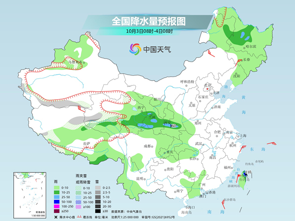
During the day today, the rainfall in West China will be reduced and weakened. Since the night of today, a new round of rainfall process has developed in West China, with moderate to heavy rain and local heavy rain in some areas; In Qinghai, Gansu and other high-altitude areas, there will be a phase change between rain and snow, with local snowstorms or heavy snowstorms. In addition, the 14th typhoon "Little Dog" this year has been strengthened to a super typhoon level and will continue to approach the southern coast of Taiwan Province Island. The Central Meteorological Bureau upgraded and issued a yellow typhoon warning this morning, and the wind and rain in Taiwan Province Island and other places will gradually increase.
Specifically, the Central Meteorological Observatory predicts that today, there will be small to medium snow or sleet in parts of high-altitude areas in northern Xinjiang, high-altitude areas along the Tianshan Mountains, southern mountainous areas in southern Xinjiang, southwestern and northern Xizang, and central and western Qinghai; There are moderate to heavy rains in parts of northern and southeastern Xizang, south-central and eastern Qinghai, south-central Gansu, central Shaanxi, northeastern Inner Mongolia, and central and western Heilongjiang. Among them, there is heavy rain (50-60 mm) in Guanzhong Basin of Shaanxi.
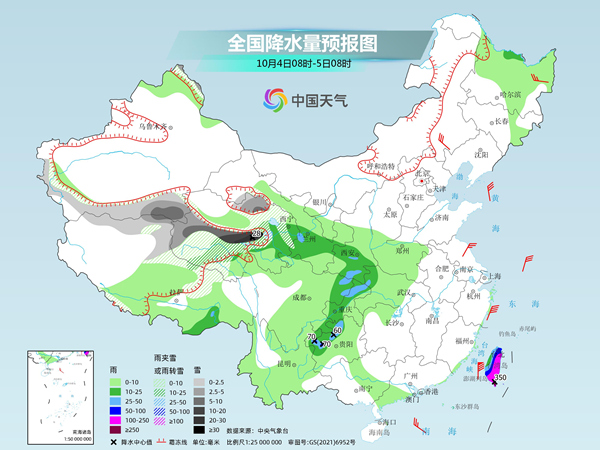
Tomorrow, there will be moderate to heavy snow or sleet in the high altitude areas of northern Xinjiang and southern Xinjiang basin, northern Xizang, eastern and south-central Qinghai, and western Gansu, among which there will be heavy snow in parts of southeastern Qinghai, with local heavy snow (20 ~ 28 mm); There are moderate to heavy rains in southern Gansu, south-central Shaanxi, northeastern Sichuan, central and western Chongqing, northwestern Guizhou, western Hubei and Taiwan Province Island, among which there are heavy rains or heavy rains in parts of northwestern Guizhou and central and eastern Taiwan Province Island, and heavy rains (250-350 mm) in the southeast of Taiwan Province Island.
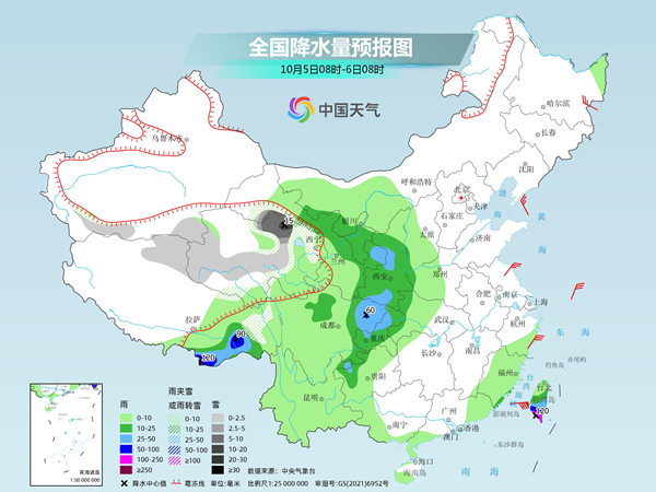
The day after tomorrow, there will be small to medium snow or sleet in parts of high altitude areas in southern Xinjiang basin, northern Xizang, south-central and eastern Qinghai, and northwestern Gansu, among which there will be heavy snow (10 ~ 15mm) in northern Qinghai and northwestern Gansu. There are moderate to heavy rains in parts of southeastern Xizang, northwestern Inner Mongolia, central and eastern Gansu, central and southern Ningxia, central and southern Shaanxi, eastern Sichuan, central and western Chongqing, northwestern Guizhou and central and southern Taiwan Province Island. Among them, there are heavy rains in parts of southeastern Xizang, northeastern Sichuan Basin and southwestern Taiwan Province Island, with local heavy rains (100-120 mm).
The meteorological department reminded that since the opening of the autumn rain in West China this year, the precipitation in Chongqing, Hubei and southeastern Shaanxi has been more than normal. In the next few days, there will still be rainy weather in the local area, so we need to be alert to the superposition effect of rainfall and the possible secondary disasters. Qinghai, Gansu and other places will have strong snowfall tomorrow, so it is necessary to guard against the adverse effects of snowfall on transportation, agriculture and animal husbandry.
The temperature in the northeast keeps falling, and bid farewell to the summer heat in the second half of the southern holiday.
In terms of temperature, affected by cold air, in the next three days, most of Inner Mongolia, Gansu, Qinghai, most of Northeast China and other places will have a temperature drop of 4 ~ 6 C, and the local temperature will drop by more than 8 C, accompanied by northerly winds of 4 ~ 6 and gusts of 8 ~ 9. Among cities, the highest temperatures in Harbin, Changchun, Shenyang and other places may hit new lows in the second half of this year. On the 5th, the highest temperatures in Harbin will be only 12℃, 15℃ in Changchun and 18℃ in Shenyang, while the lowest temperature may drop to about 5℃. Please pay attention to adding clothes at the right time in the later period of public holidays to guard against colds.
From 5th to 7th, the temperature in the south will also decline, bidding farewell to the hot weather. For example, in Guiyang, the highest temperature will be 29℃ today and only 21℃ on the 6th. The highest temperature in Fuzhou will reach 32-33℃ today and tomorrow, and will drop to 24℃ on the 6th, which is quite comfortable.
关于作者